Attendees: Myself and my father
Mode of transportation: car
Overview of our trip.
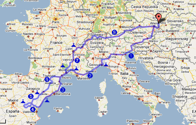
Leg #1 – Malacky – Genova (IT)
My father and I started our trip on Saturday April the 28th. Drove through Vienna/Klagenfurt in Austria, crossed border with Italy and headed south to Udine and Venice. We crossed the Po river near Cremona. The broad Po river valley was lush green with the freeway lined up by fields and small patches of poplar forests – to “grow” pulp most likely. Italian farm houses are big – 2 to 3-stories tall, surrounded by cyprus trees (that’s what they looked like from the distance) that contrast nicely with the flat fields surrounding them. The country is not flat-boring as the fields are not large like in the US and are separated by creeks and rivers, shrubs and the above-mentioned small forests.
After crossing the Po river we turned south on highway A7 to Genova crossing the surprisingly high Apenino Ligure montain range. Couple of dozens of miles before reaching the city we got off the freeway and drove east towards a small town Montogio where the map indicated presence of a camping place. Given the steep slopes and narrowness of the valley that lead us to Montogio it was hard to imagine there would be a place for a camp site, but after driving through steep and narrow streets of the village we found it. It was pretty basic, but given that we were to spend there only one night and it was late when we arrived, we found it acceptable.
Leg #2 – Genova – San Remy (FR)
In the morning we packed the tent and took off towards Genova. We made a decision to try to get to France with spending as little time in Italy as possible as Spain was far away, so we did not stop in Genova. We managed to take a wrong turn, but after finding our mistake we were on our way – driving the highway A10 to France along the Riviera di Ponente.


Couple of pictures of Genova from the freeway
The freeway is an engineering marvel as the whole 200 km stretch between Genova and Monaco is a collection of tunnels and bridges with hardly any “regular” segments in between. For lunch we decided to get off the freeway near Monaco to get a feeling what the Cote D’ Azur looks like from up-close. We ended up in town of Menton. It was what we expected after what we saw from the freeway – an uninterrupted development along the coast that tended to concentrate in small towns like Menton. At the time of our visit the town was not crowded with turists, but it was obvious that at the height of summer season the place must be packed – we even managed to find a parking space on one of the steep streets in the old part of the town. After having lunch (I had a very well-made gnocchi and my father had “fruit of the sea” paella) we returned to the freeway and continued on our way towards Avignon.

A street in Menton
In Aix we entered Provence and the landscape character had changed – we started to see limestone ridges and plateaus. It looks like sediments from the bottom of an ancient sea were uplifted in this part of France several hundred feet above the water level to give the region its distinct look. Around 5 pm we took off from the freeway A7 just south of Avignon and headed to St. Remy where we planned to spend a night.

The road from Cavaillon to St. Remy was lined with old, tall maple trees – we encountered these alleys all around Provence and even in Spain. In many places people seem to cut the branches off the trees (in the fall?) and leave just stumps of thicker branches, which sprout new branches in the spring, creating very distinct tree shapes.
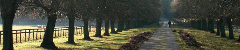
The camp site in St. Remy was easy to find and nice. What a difference from the crowded camp site we spent the last night in – for the same price about 20 euro the facilities were much nicer with more room between tent places, clean facilities and even an internet access. After arriving we immediately took bicycles off the car roof, changed clothes and took off for a ride. Just south of St. Remy is an interesting little mountain ridge called Des Alpilles. The limestone layers from which the ridge is built are perpendicular to the Earth surface which – together with erosion – lead to the ridges sticking out of the otherwise flat-ish surrounding landscape like teeth.


Biking in the Alpilles
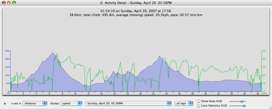
bike ride profile
The bike ride was a little hilly with quite steep climb right after leaving St. Remy, but it was worth it – once we got to the other side of the ridge, the landscape was spectacular. Irrigated by canals that bring water from the east the south slopes of the ridge are a patchwork of vineyards and old olive orchards. The nice big houses suggested that the area was populated by well-to-do people who most likely worked in Avignon, Arles or other bigger cities in the region. Another possibility is that agriculture in France is a good business.
Leg #3 – San Remy – La Ampolla (SP)
Around 8am – right after the gate from the camp was opened we headed north to see Avignon. We did not plan to step out of the car because we wanted to make it to Spain that day, but wanted to see the city. Because it was morning time and the summer season was still couple months off in the future, the city was fairly empty. We planned to drive around its fortified old part, but by accident took turn to a street that lead us directly to its heart. The old city – as expected is a lovely labyrinth of narrow streets with virtually no modern development.

Avignon
From Avignon we drove through Nimes and Montpelier to Perpignan. There we left the freeway as we wanted to cross the border with Spain on a small road leading along the coast. This turned out to be worth the delay, as the eastern end of the Pyrenees meeting the mediterranean creates a lovely scenery. This was also the least populated segment of our along-the-mediterranean route so far.
After lunch that we cooked at a rest place next to the road from ingredients bought in a Perpignon supermarket we continued to Figueres, passed Barcelona and ended in the town of L’ Ampolla on the northern edge of the Ebro river delta. After finding a spot in the camp at the edge of the town we took off on bicycles to check the delta. The area is a huge expanse of barren-looking agricultural land. All around we saw shallow fields separated from each other with half-a-meter high earth mounds which apparently were set up to be irrigated by openings in the sides of irrigation canals. Later we learnt that these are rice fields and the Ebro delta is a major rice producer. From time to time we passed by small houses surrounded by a vegetable garden. These seemed to be just weekend retreats where people went to relax by gardening. Most of the houses looked shabby, but the vegetables in the gardens were huge. In the town of Deltebre we crossed Ebro on a ferry driven by a guy that was trying to tell us something but given that he spoke spanish and very fast at that, we had no idea what he was saying. Possibly he was telling us that it is getting late and we would not be able to cross the river on his boat if we did not come back soon. Our plan was to bike on the other side of the river north and cross it in the city of Amposta, so that warning was not of interest to us. After fighting the western headwind we reached Amposta where we crossed the river on a very busy road from which we got off as soon as possible on the other side. Not having a good map we were finding our way back to the camp only by keeping direction towards our starting point as indicated by my GPS. The region between Amposta and L’ Ampolla is lined by vegetable fields – we saw artichokes, cauliflower that was apparently picked just recently, onions and other kinds of vegetables, all of impressive sizes – a testament of fertile deposits of the Ebro river. It was night when we arrived to the camp, but the trip was a success as it was crowned by having a beer and hot chocolate in the camp restaurant.
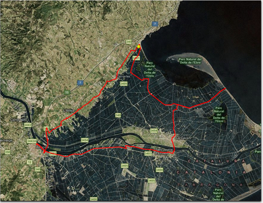
Ebro delta bike ride path
Leg #4 – L’ Ampolla – Cuenca (SP)
Originally we planned to drive down to the town of Moraira to meet friends from the US, but after they told us they were heading to Cuenca we changed our plan and decided to meet them there instead. This was going to save us a day of driving south as well as bring us to the central Spain that we wanted to see.
After leaving L’Ampolla we drove on the E15 to Castellon where we took the road through Onda north-east into the interior. The well-paved road between Castellon and Onda was lined-up with newly-built warehouses – a testament of the economic boom Spain has been going through in recent years, probably as a consequence of economic help it has been getting from the EU. This is likely the same phenomenon that many east-european countries like Slovakia are currently experiencing.
After many hours of driving we reached Cuenca. The weather was rainy and it was quite cold – also due to the elevation, as the city is located on a huge, pine tree-forested plateau about 1000 meters above the sea level. The country around Cuenca reminded me a lot of Sierra Madre mountains around Creel in Mexico that I visited last year. After finding a camp several km north of Cuenca and setting up our tent, we drove back to the city to meet our friends.

Lunch spot on a plateau close to Teruel
The old Cuenca is spectacular. It is built on a narrow limestone ridge carved-up into a surrounding plateau by two rivers. We walked its streets for couple of hours and them ended up in a small restaurant where we had traditional spanish tapas for dinner.


Walking the streets of Cuenca
Leg #5 – Cuenca – Caspe (SP)
Given the rainy and cold weather we decided to slowly head back north to France, so we started to drive through the spectacular Serrania de Cuenca mountains towards Teruel. Just a couple of kilometers north of the cam we stopped by the road to check the Ventano del Diablo (the Devil’s window). It is a canyon with caves and rock arches carved out by the Jucar river. It would have been a great area to explore on bicycles, but we will have to come back some other time as the weather was pretty bad the time we were there.

Ventano del Diablo
Driving north of Teruel we encountered landscape similar to the dry expanses of the American West – the rock is not volcanic but sedimentary and its european location is also given up by the presence of olive trees, but the arid character, the shapes of mountains and the lack of population all reminded me strongly of places like eastern Washington. Before reaching the town of Montalban we drove through some mining towns like Escucha. Google revealed that coal is mined in the surrounding area.

We saw no windmills, but plenty of wind turbines in the land of Don Quiote
Before reaching Alcaniz we descended to lower elevations of around 500 meters above the sea levels and because the weather was much better than in the Cuanca mountains we decided to stop and go for a bike ride along the Guadalope river. The route from the town of Torre Castiel to Castellote was on our Michelin atlas of Spain indicated as scenic. This turned indeed to be a fact – from the Calanda reservoir where we started the ride the road was slowly ascending along the valley only to seemingly end up in a sheer rock cliff before we reached the town of Castellote. Around the last bend of the road we found ourself facing a tunnel entrance and the mistery was solved. Immediately on the other side of the tunnel starts Castellote which is a typical Spanish small town with narrow streets and several-stories tall building. After taking a break we returned the same way back to the start of our trip.

Small church at the end of the canyon just before entering the tunnel leading to Castellote


The streets of Castellote

On the shore of the Calanda reservoir where we started and ended our bike ride
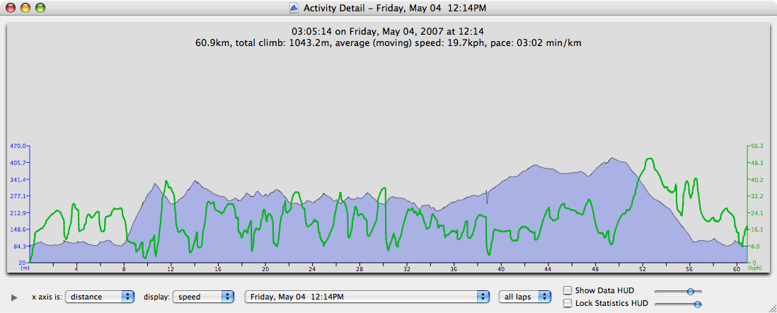
Bike route profile
After finishing our ride we continued driving to Alcaniz and Caspe north of which we found a camping site at the edge of another reservoir, this time on the Ebro river. This is the place where I saw my biking shorts and jersey for the last time as I forgot to take them from the camp bathroom after taking a shower. The camp was quite nice, but we arrived too late to investigate the surroundings.
Leg #6 Caspe – Ganges (FR)
In the morning we departed around 8 am north towards Lleida where we took highway C14 to the Pyrenees and Andorra. Before entering this mini-state we read that there are no sales taxes there, which turned the valley into one huge shopping mall. As we drove through it, this seemed to be fact as from the road all we saw were car dealerships and huge billboards advertising great deals to be had for all kinds of goods. The only monetary benefit we gained was a full tank of the least expensive gas of our entire trip – around 0.96 euro/liter, which is even less that cost of gas in Slovakia. The whole valley seemed to be experiencing a building boom as we saw cranes everywhere, building new hotels, apartment buildings and shops, even on the most impossibly steep slopes. The northern end of the valley is rimmed by the highest ridges of the Pyrenees. Here the Andorrans built a big ski center.
After crossing the ridge we descended down to France. In the old town of Foix we made a lunch break. Then we continued to Carcassone and near Narbonne joined the A9 highway that we took on the way south to Spain couple of days before. The weather was getting worse since we left Andorra and in Montpellier it was raining buckets. The original plan was to arrive to somewhere north of Montpelier and do another biking trip, but given the rain all we managed to do was to find a bed and breakfast in a small town of Ganges, crash into beds (a nice change from sleeping on the ground in sleeping bags for couple of straight nights) and watch TV – which was a refreshing experience as we have not had access to the news for several days.

Our room at the bed and breakfast in Ganges – Provence.
Leg #7 – Ganges – Pont-d’ Ain (near Lyon) (FR)
In the morning we packed our stuff and descended to the small restaurant on the first floor to have a breakfast. This turned to be a different experience from what we were used to from bed and breakfast places in the States. We had no clue when was serving of the breakfast over so after a while I went to the kitchen to ask only to learn that the coffe, tea, a basket with couple of rolls and one serving of jam and butter was all we were going to get. This seemed an inadequate amount of food for 2 grown men – especially ones from Slovakia 🙂 spoiled by the breakfast spread in the US b&b-s. The place was otherwise nice and clean, but I hope this is not a typical situation in France’s hotels.
The skies were cloudy as we drove north towards Ales. However, it was not raining and there seemed to be some breaks in the clouds north where we were heading. So we found another route marked as scenic on our map of Provence to go biking on if the weather was going to be cooperating when we reached its start.
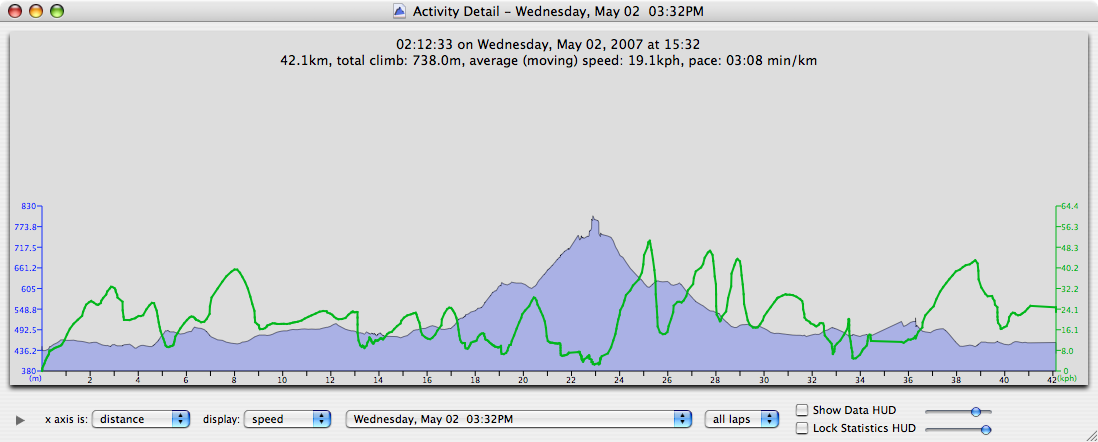
When we reached the town of Vallon-Pont-D’Arc the skies were cloudless above us and the air was worm. We left the car at a small parking lot next to the river that was getting used by a bunch of kayak enthusiasts to practice their skills on a white-water run that was built on the left side of the river. The whole area, with its myriad boat-renting and rafting trip guiding establishments seems to be a big attraction in the summer months for people from all around the world. Fortunately at the time of our visit there were very few people.
The road that we took is winding along the river Ardeche, which carved deep canyon into a huge limestone plateau. The route begun gently, only to start climbing steeply at some point all the way up to the top of the plateau from which we got great views of the river.


Ardeche river canyon

Taking a break after descending from the Plateau des Gras
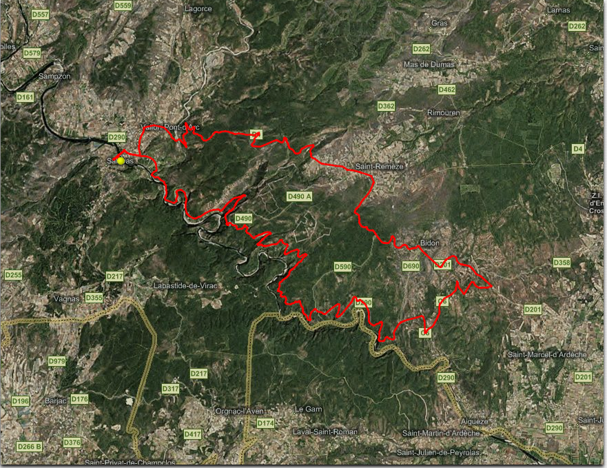
The bike ride path
The bike ride profile
After completing our bike ride we headed north towards Lyon. Just before reaching it, we took an exit to look for a camp site that was marked on a map next to town Vienne, but we did not find it. After driving for an hour without knowing where exactly we were, looking for a camp site, we found our way back to the freeway heading west to Geneve in Switzerland. We stopped at a gas station and learned about several camp sites just off the highway near Pont-d’ Ain. We found the camp site quite easily, put up a tent and went to sleep as it was dark already.
Leg #8 – Pont-d’ Ain – Malacky (SK)
It was raining on and off the whole night and we woke up around 5 am. An unanonymous decision was made to pack the tent and head back home. However the camp was closed until 7am so we had to wait for an hour. To make the best of the time I crossed the river Ain and went to the town where I bought some bread and fine french pastries. After returning back the gate was open and we took off to the last – and the longest drive of our trip that took us through France, Switzerland, Liechtenstein, Germany and Austria back home. It was raining the whole time – in places so hard, that the police had to divert traffic from the freeway to rural roads to avoid some rain-induced blockage on the freeway. We arrived home shortly after midnight.
Technorati Tags: Movie